
| |
| Ste. Marie, Michigan
| |
|---|---|
| Country |
|
| Founded |
1671 |
| Mayor |
Pat Quinn (D) |
| Elevation |
594 ft (181 m) |
| City population |
717,157 (2013)
|
| Metro population |
983,681 (2013)
|
Ste. Marie is Michigan's most populous city,[1] located at the northern tip of the Lower Peninsula. With Lake Michigan to the west and Lake Huron to the east, Ste. Marie is one of the busiest ports in the Great Lakes region. As of a 2013 estimate the Ste. Marie-St. Ignace metropolitan area had a population of 983,681.[2] The city's population was estimated to be 717,157.[2] As of a 2011 estimate, Ste. Marie surpassed Detroit as the most populous city in Michigan, when Detroit's population was estimated as 705,633 and Ste. Marie's was 712,402.
Located to the immediate west of Ste. Marie in Lake Michigan is Bay Ste. Marie, for which the city is named.[3] The city is known for its French and Creole heritage. Ste. Marie is notable for its influential foods and French colonial architecture, both of which attract millions of visitors to city every year.[4]
Ste. Marie is located in both Emmet and Cheboygan Counties in Michigan. It is the seat of both counties.[1] Its location on the shores of Lake Michigan and Lake Huron form a half-moon shape. It is bordered by Charlevoix and Otsego Counties to the south, Mackinac County to the north, Lake Michigan to the west, and Presque Isle County to the east.
History[]
- Main article: History of Ste. Marie, Michigan
|
|
Colonial era[]
The land at the tip of the Lower Peninsula was previously settled by the Odawa before the arrival of the French. Ste. Marie was founded in 1671 by Jacques Marquette and several other Jesuit missionaries. In 1734, Marie-Joseph Angélique allegedly started a great fire that burned most of the city. In the aftermath of the fire, most of Ste. Marie's monumental architecture was constructed.
Ste. Marie's only contribution to the French and Indian Wars was a number of French garrison sent to fight throughout New France. Nevertheless, the city was ceded to the British on February 10, 1763, under the Treaty of Paris. Sooites (a nickname branded by the French) resisted the British's strict rule of the city from 1763-1779. The Bloodless Rebellion of 1779 liberated the city from British rule and in 1783, Ste. Marie became part of the young United States.
On July 13, 1787, Ste. Marie became the capital and largest city of the Northwest Territory. Included in the Northwest Ordinance was the prohibition of slavery in the territory, liberating a total of 1,340 black slaves and bringing the total of free blacks in Ste. Marie to 2,472 of the total population of approximately 13,000.
19th century[]


The Battle of Ste. Marie (1814)
In 1812, the British captured nearby Fort Mackinac and occupied Ste. Marie. The Battle of Ste. Marie in 1814 was lost by the Americans, and to prevent an uprising in the city of 20,000; Ste. Marie was placed under martial law. The British retreated from the area months later in December 1814, and Ste. Marie was returned to American control on February 18, 1815.
On July 21, 1818 an earthquake with an intensity of M ~7.0 – 8.0 shook the city of Ste. Marie at around 2:15 a.m.[5] The city which had been infamous for hastily, and often poorly built infrastructure experienced major damage. Fires were ignited by ruptured gas lines, which were particularly damaging in the poor, working class neighborhood south of the Place d'Buade. Approximately 27[5] aftershocks were recorded until the "Daylight Shock" was felt at 8:15 a.m., which was of the same intensity as the first.[5] The earthquake of 1818 killed a recorded 498 individuals,[6] but the toll may have been well over 750.[7] 31,000 of the city's 33,445 were left without a habitable place to live.[6]
Rebuilding and rebirth were rapid in the city's hardest hit districts and all elsewhere, due to a strong growth of industrial jobs. Germans, and later Irish immigrants passed through Mackinac Island in search of a better life. Segregation in Ste. Marie was based less on race than it was on money and social status. Many blacks from southern states sought freedom and opportunity in Ste. Marie in the years before the Civil War. In addition to blacks, white French Canadians began immigrating to the city after 1840; and by 1930 over 340,000 French Canadians had started a new life in Ste. Marie.[8]


The Springfield Armory in 1864.
Ste. Marie served as the Union's farthest stronghold from the fighting in the south during the Civil War. The Mackinac Arsenal on Mackinac Island was one of the largest arsenals in the Union, which doubled as a large Union army prison camp during the war years.[9] The Springfield Armory, the largest manufacturer of riles in the Union, employed thousands of workers during the Civil War. Due to Ste. Marie's importance during the war, the National Civil War was founded at 2061 Barrin Street in 1905.
20th century[]
21st century[]
Much of Detroit's population loss before 2010 relocated to Ste. Marie, where jobs were more plentiful and living standards were better. An earthquake in 2008 did little to slow population growth, and little signs remain of this earthquake.
2014 Waugoshance earthquake[]
- Main article: 2014 Waugoshance earthquake
Geography[]
Demograhpics[]
Increasing population[]
Starting in the mid-2000s, Ste. Marie experience population growth due to several factors. Many residents who came to live in Ste. Marie after 2005 came to avoid rising poverty and closures of many manufacturing centers in Detroit. Ste. Marie also saw a rising job market, with a Chrysler facility opening in 2007. In 2000, Ste. Marie's population was 688,701, which rose to 702,513 in 2010.
After the 2014 earthquake, population, estimated by use of city services on December 27, had fallen to about 402,865, 56% of the October 19, 2014 population of 719,401. The Census Bureau has rejected the December 27 calculation as inconclusive, as many people have yet the chance to return to their homes and decide whether or not to rebuild.
Economy[]
Other[]
Culture[]
Music[]


A Bix poster, circa 1927.
Ste. Marie has been a center for music in the United States since the early 1920s when Swing and 1920s Jazz were developed in the city. A pioneer of Ste. Marie's music was Bix Beiderbecke, a Ste. Marie native of German ancestry who formed The Wolverines in various dancing halls in Central City. Jazz grew to become synonymous with Ste. Marie in the "Jazz Age" when America sought new music.
While Ste. Marie Jazz (Northern Jazz) shares many qualities with New Orleans Jazz, there are several differences. Northern Jazz was said to have invited, rather than commanded you to listen - perhaps due to a simple difference in slave culture of the colonial era, where slavery in the Ste. Marie was ended far before it was in New Orleans.
Food[]
Ste. Marie is often referred to as the birthplace of America's food. Indeed, many popular dishes eaten across the country today originated from the diverse pallet of Ste. Marie. Most notably is Ste. Marie's take on hamburgers, with thicker patties of beef, thick French bread buns; topped with ingredients such as pickle relish and varieties of Great Lakes seafood. These are then topped with des allemands (of Germany), which is a flavorful, salty seasoning that is very recognizable and widely used in other dishes of the city.
A form of chili was also developed by poor Creole slaves in the mid 18th century containing no spices - unlike Texas style chili. This is commonly served in the fall and winter months, while French bread sandwiches loaded with chicken and roast beef are served during the spring and summer. Other soups, such as potato and minestrone, were developed by Irish immigrants in Ste. Marie throughout the 19th century.
Sports[]
National protected areas[]
Government[]
Education[]
Media[]
Transportation[]
Earthquake vulnerability[]
Being at the northwest end of the Les Cheneaux fault line, Ste. Marie is very vulnerable to earthquakes. After a 5.4 magnitude quake caused damage in the city in July 2008, the Federal Emergency Management Agency warned that a stronger earthquake could result in "the highest economic losses due to a natural disaster in the United States," further predicting "widespread and catastrophic losses," for the Ste. Marie metropolitan area and the states of Michigan, Indiana, Wisconsin, and southern Canada.[10]
Beginning in February 1989, climatologist Iben Browning – who claimed to have predicted the 1980 eruption of Mount St. Helens, and the 1989 Loma Prieta earthquake predicted that there was a 50 percent probability of a magnitude 6.5 to 7.5 earthquake in the Ste. Marie area sometime between December 1 and December 5, 1990. Although the prediction attracted the national media's attention, the period passed with no significant seismic activity.[10]
Fictional 2009 Les Cheneaux earthquake exercise[]
- Main article: 2009 Les Cheneaux earthquake exercise
The University of Michigan, funded by FEMA, conducted a study in January 2009 known as the "2009 Les Cheneaux earthquake" with the goal of accelerating earthquake planning in Michigan and understanding the Les Cheneaux Seismic Zone. The fictional earthquake was an M 8.2, which has a 6% probability of occurring within the next 50 years. The quake would cause upwards of $300 billion of damage in metropolitan Ste. Marie and cause 86,000 casualties and 4,500 fatalities. 515,000 buildings would be damaged or destroyed. 700,000 people would be displaced.[11]
Head of the study, Amr S. Elnashai, ruled that such a scenario would cause a tsunami in Bay Ste. Marie, but due to a natural bluff surrounding the city, only the immediate coast would be flooded. The team evaluated that Ste. Marie's largely defunct and poorly planned infrastructure would be utterly destroyed by such an earthquake. This would affect the shipping industry, transportation, and water distribution throughout the eastern half of the nation.[11]
Earthquake preparedness[]
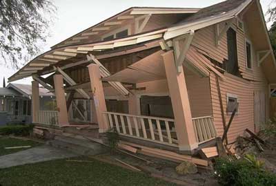

Damage to a home caused by the 2008 earthquake.
- Main article: Earthquake preparedness of Michigan
To prepare for an event of this magnitude, the team suggested that 750 shelters with medical services be prepared to operate for 100 days after the initial shock. 5,000 buses would be needed to transport displaced individuals to habitable locations.[11]
To prevent the catastrophic damage, Ste. Marie building code would need to be updated to demand retrofits for unstable buildings. City infrastructure, such as sewer systems and transportation, would need to be updated to withstand a major earthquake.[11]
Les Cheneaux earthquakes have become increasingly frequent since the 2008 shock. In a December 19th, 2014 statement, the USGS warned that the Mw 3.9 shock on December 13th may be a foreshock to a larger quake that could strike in January 2015. 80% of the city lost power during this relatively weak earthquake.
The poor performance of city infrastructure on December 13th has led to frequent inspections by city agencies to prevent devastation if a major earthquake should strike in 2015. Mid American Energy, the Ste. Marie metropolitan area's main electricity provider, has assured critics that the shock simply caused the backup generators to turn on, causing nearly 30 explosions at substations in the city, and that the problem has been fixed.
Notable people[]
Nicknames[]
Sister cities[]
References[]
- ↑ 1.0 1.1 Demographics of Ste. Marie
- ↑ 2.0 2.1 2013 Michigan Population Data
- ↑ Ste. Marie Name Etymology
- ↑ Ste. Marie Tourism Bureau
- ↑ 5.0 5.1 5.2 The Great Earthquake of 1818
- ↑ 6.0 6.1 Aftermath of the Earthquake of 1818
- ↑ Census of 1820
- ↑ French Canadian Emigration to the United States
- ↑ Ste. Marie in the Civil War
- ↑ 10.0 10.1 USGS: Les Cheneaux Seismic Zone
- ↑ 11.0 11.1 11.2 11.3 2009 Les Cheneaux earthquake exercise